Redwood Canyon, Hart Tree Trails
The largest sequoia groves on the planet are found in Redwood Canyon in Kings Canyon National Park. More than 15,000 big trees spread over 4,000 acres and hiking is the only way to visit them.
Sixteen miles of trail weave among the extensive old-growth groves and meander along Redwood Creek. The trails offer hikers a kind of wilderness experience not possible from the awesome, but extremely popular groves in Sequoia National Park.
From a hiker’s perspective, the sequoias en route sure seem more densely congregated than elsewhere in the park. The sequoia’s creek-side companions are quite colorful: in spring, dogwood blooms along with purple lupine, and in autumn the forest lights up with the red and gold leaves of the aspen.
Sequoias aren’t the only big trees in Redwood Canyon. Sugar pines can be as tall or taller than neighboring sequoia and have much larger cones—measuring 10 to 24 inches long—longest of all trees.
If you’re short of time, hike out and back through Redwood Canyon—a 4-mile round trip jaunt on a trail paralleling Redwood Creek. Otherwise choose among stellar loop trips with plenty of sights to see: Tunnel Tree (the trail goes through it), Hart Tree (a top 20 sequoia), and a hollowed-out sequoia once used as a cabin.
My favorite loop visits Hart Tree and Fallen Goliath and returns via Redwood Canyon. Consider a longer return through the Sugar Bowl, characterized as “a grove within a grove,” for its dense stands of young sequoia.
DIRECTIONS TO THE REDWOOD CANYON TRAILHEAD
From the Big Stump entry to Kings Canyon National Park, continue on Highway 180 1.5 miles to Generals Highway. Turn right and drive 3 miles to Quail Flat and a junction with the paved road to Hume Lake on the left. Turn right on dirt Redwood Saddle Road, descending amidst great sequoias 1.7 miles to a junction; fork left to the parking lot and signed trailhead.
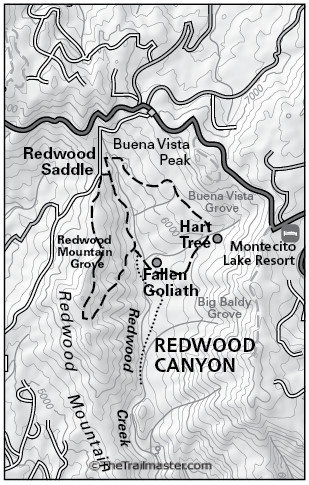
Redwood Canyon Map by TomHarrisonMaps.com (click to enlarge)
THE HIKE
Walk down the wide forest path 0.3 mile to a signed junction. Bear left, crossing and re-crossing tributaries of fern-lined Redwood Creek. About a mile out, reach Barton’s Post Camp, site of a logging operation in the late 1800s.
Hike another mile to lush and lovely Hart Meadow, and then to and through Tunnel Tree (a hollowed-out sequoia log) to meet the short (100-yard) spur trail to Hart Tree at the 3.2-mile mark. After visiting the tree, largest in the grove, return to the main trail and descend to Fallen Goliath, a truly ancient tree now serving as a “nursery log” for young sequoias.
The path descends to Redwood Creek and a junction with Redwood Canyon Trail. Head right, up-creek and soon (0.1 mile) reach a junction with Sugar Bowl Trail; go left to extend your outing with a hike up and around Redwood Mountain. Otherwise continue up-canyon parallel to the creek. When you return to the junction with Hart Tree Trail, bear left and retrace your steps to the trailhead.
Interested in more hikes in Sequoia and Kings Canyon? Check out my guide: HIKE Sequoia and Kings Canyon