What’s not to like about a fairly flat footpath that leads through lovely forest, across wide meadows and ends at a drop-dead gorgeous overlook above the ocean? No wonder Bear Valley Trail, a former wagon road, is one of the most popular paths in the national seashore.
DIRECTIONS
Bear Valley Visitor Center is located just outside the town of Olema, 35 slow and curving miles north of San Francisco on Highway 1. A quicker route is by Highway 101, exiting on Sir Francis Drake Boulevard, and traveling 20 miles to Olema. Turn right on Coast Highway 1, proceed 0.1 mile, then turn left on Bear Valley Road, which leads 0.4 mile to parking for the Point Reyes National Seashore Visitor Center and the trailhead.

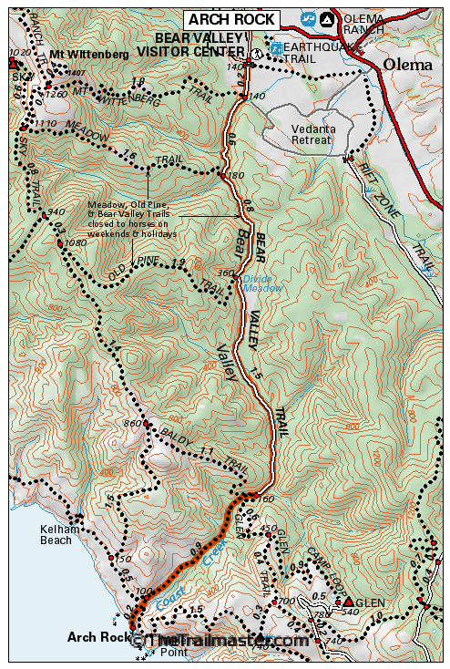
Point Reyes – Bear Valley Hiking Map by TomHarrisonMaps.com (click to enlarge)
THE HIKE
Bear Valley Trail leads through open meadow and, after 0.2 mile, passes a junction with Mt. Wittenberg Trail, which ascends Mt. Wittenberg.
Beyond this junction, the trail enters a forest of Bishop pine and Douglas fir. Your path is alongside Bear Valley Creek. Notice that the creek flows north, in the opposite direction of Coast Creek, which accompanies Bear Valley Trail from Divide Meadow to the sea. This strange drainage pattern is one more example of how the mighty San Andreas Fault can shape the land.
A half-mile along, pass a junction with Meadow Trail and, after almost another mile of travel, arrive at Divide Meadow, 1.6 miles from the trailhead. Well-named Divide Meadow divides Bear Valley Creek from Coast Creek. Bordered by Douglas fir, the meadow is a fine place for a picnic, as well as being a popular destination/turnaround point for many hikers. It’s also, literally, the hike’s high point (about 360 feet above sea level).
Re-entering the forest, shady Bear Valley Trail continues another 1.5 mile to a junction with northbound Baldy Trail and southbound Glen Trail. At the 3.2-mile mark, Bear Valley Trail narrows from road to footpath (from which bikes are banned), and heads for the coast in the shade of Douglas fir.
Four miles along, the trail ends at a junction with Coast Trail. Follow the signs to Arch Rock, past a second junction with Coast Trail.
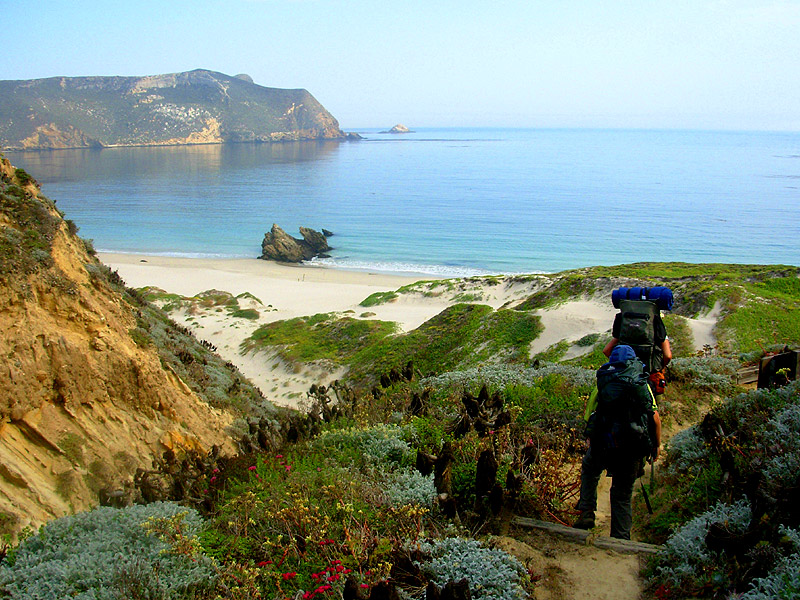
Near the ocean, the path crosses through coastal scrub and arrives at an open meadow on the precipitous bluffs above Arch Rock. Unpack your lunch and admire the sea stacks.
Careful hikers can reach the arch by following a sketchy, eroded path down to Coast Creek, and then scramble over rocks to the ocean. The arch is accessible at very low tide. Keep an eye on the tides because you don’t want to get stranded on this beach.
Be warned, though: Arch Rock, in the National Park Service view, is an overlook point with no beach access. For hikers who have just got to get to the beach, The Trailmaster recommends heading for Kelham Beach, accessible from Kelham Beach Trail, 0.8 mile north on Coast Trail.
Interested in more hikes in Point Reyes National Seashore? Check out my guide: HIKE Point Reyes.