TRAILS

  • San Miguel Island

    San Miguel Island

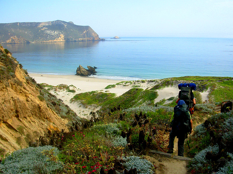
    San Miguel, westernmost of the Channel Islands, has much to offer the hiker, particularly if you join a ranger-guided hike.

    Hiking down to Cuyler campground on San Miguel Island. (Todd Clark)
    Hike to Cuyler campground on San Miguel Island.(Todd Clark)

    Eight miles long, four miles wide, it rises as a plateau, 400 to 800 feet above the sea.

    Wind-driven sands cover many of the hills, which were severely overgrazed by sheep during the island’s ranching days. Owned by the U.S. Navy, it was used as a bombing site and missile tracking station.

    San Miguel is home to six pinniped species: California sea lion, northern elephant seal, steller sea lion, harbor seal, northern fur seal and Guadalupe fur seal. The island may host the largest elephant seal population on earth. As many as 15,000 seals and sea lions can be seen basking on the rocks during mating season.

    San Miguel offers some great hiking, and guided hikes. Cuyler Harbor Beach, Cabrillo Monument and the Lester Ranch site are the sights you can see on your own. From Cuyler Harbor, the hike to Lester Ranch is about 3 miles round trip with 700-foot elevation gain.

    Rangers and naturalists offer guided hikes to other parts of the island, soon after Island Packers boats arrive on San Miguel.

    A trail extends most of the way from Cuyler Harbor to the west end of the island at Point Bennett, where the pinniped population is centered. Trails pass the island’s two round peaks, San Miguel and Green Mountain, drop in and out of steep canyons and traverse the caliche forest, composed of fossil sand casts of ancient plants. Calcium carbonate reacted with the plants’ organic acid, creating a ghostly forest.

    PLANNING TO GO TO SAN MIGUEL ISLAND?

    Plan a very long day—or better yet, an overnight trip to San Miguel. It’s at least a five-hour boat trip from Ventura. Boat over to the island with Island Packers (805) 658-5730, the Channel Islands National Park primary concessionaire. Island Packers offers plenty of free parking, a gift shop and restrooms.

    For more information contact Channel Islands National Park or stop in at the visitor center (805) 658-5730 in Ventura Harbor at 1901 Spinnaker Drive.

    THE HIKE

    Follow the beach at Cuyler Harbor to the east. The harbor was named after the original government surveyor in the 1850s. The beach around the anchorage was formed by a bight of volcanic cliffs that extend to bold and precipitous Harris Point, the most prominent landmark on San Miguel’s coast.

    At the east end of the beach, about 0.75 mile from anchoring waters, a small footpath winds its way up the bluffs. It’s a relatively steep trail following along the edge of a stream-cut canyon. At the top of the canyon, the trail veers east and forks. The left fork leads a short distance to Cabrillo Monument.

    You will be able to see the trail above the east side of the canyon. When you get to the top of the canyon the ranger station and pit toilet are straight ahead. Instead of going straight you can turn east. The trail ascends a short distance to the Cabrillo Monument. The Lester Ranch is a short distance beyond that.

    Juan Rodriguez Cabrillo, Portuguese explorer, visited and wrote about San Miguel in October 1542. While on the island he fell and broke either an arm or a leg (historians are unsure about this). As a result of this injury he contracted gangrene and died on the island in January 1543 and it’s believed (historians disagree about this, too) he was buried here. In honor of Cabrillo, a monument was erected in 1937.

    The right fork continues to the remains of a ranch house. Of the various ranchers and ranch managers to live on the island, the most well known were the Lesters. They spent 12 years on the island and their adventures were occasionally chronicled by the local press.

    When the Navy evicted the Lesters from the island in 1942, Mr. Lester went to a hill overlooking Harris Point, in his view the prettiest part of the island, and shot himself. Within a month his family moved back to the mainland. Not much is left of the ranch now. The buildings burned down in the 1960s and only a rubble of brick and scattered household items remain.

    Interested in more hikes near San Miguel Island? Check out HIKE the Channel Islands

  • Baldwin Hills Scenic Overlook State Park

    Baldwin Hills Scenic Overlook State Park

    Even on a foggy morning or smoggy afternoon, the vistas from Baldwin Hills Scenic Overlook take in a remarkably wide circle of the metropolis. You can see buildings near and far, from the triangular-shaped Culver City Hotel and Sony Pictures complex in Culver City to the office towers of Century City and downtown L.A. Plus the San Gabriel Mountains, Hollywood Hills and Griffith Observatory, Santa Monica Bay and Catalina Island.

    You can't miss the trailhead and entry to Baldwin Hills Overlook State Park.
    You can’t miss the trailhead and entry to Baldwin Hills Overlook State Park.

    You won’t see many nearby parks from the overlook, though; about three million people live in the 5-mile area surrounding the Baldwin Hills and there’s less than one acre of parkland for every 1,000 people. A decade-long conservation effort and more than $40 million saved the hills from a large residential development. Baldwin Hills Scenic Overlook State Park opened in 2009.

    More good news about the new state park: “Baldwin Hills” is back as a place name. The parkland on the east side of La Cienega was known as Baldwin Hills State Recreation Area until 1988 when the state legislature renamed it for longtime Los Angeles County Supervisor Kenneth Hahn. In The Trailmaster’s experience, parks named for predominant geography are far easier to remember and locate than those named for politicians.

    Well-named Hillside Trail and a long, long flight of stairs explore Baldwin Hills Scenic Overlook State Park. From Jefferson Blvd. to the Overlook it’s a 2-mile round trip hike with 300-foot elevation gain.

    Baldwin Hills Scenic Overlook State Park
    Hillside, Stairs Trails

    From Jefferson Blvd. to Overlook is 2 miles round trip with 300-foot elevation gain

    At the top of the 68 acre-park is a visitor center (rarely staffed) and a large parking lot (rarely used). Slopes desecrated by dozers have been re-graded to natural contours and replanted with native flora.

    Stairway to Heaven--or at least to the top of Baldwin Hills Overlook State Park.
    Stairway to Heaven–or at least to the top of Baldwin Hills Overlook State Park.

    This is a park for walkers, hikers and joggers, who begin their workouts at the bottom of the hill and hoof it up to the overlook. Reach the overlook by way of a mile-long trail or 300-plus stone steps that head straight up to the summit. Enjoy this as an early morning nature hike or get a great late afternoon workout with some bootylicious stair-climbing cardio.

    Baldwin Overlook has been called the “Runyon Canyon of Culver City” because both locales offer popular end-of-the-day workouts of an hour or so and superb vistas. A big difference is Baldwin (being a state park) does not allow dogs while Runyon is overrun with canines.

    Directions: From the Santa Monica Freeway (10) in Los Angeles, exit on La Cienega Boulevard and drive south 0.7 miles to Jefferson Boulevard and turn right. (Continuing another mile south will take you to Kenneth Hahn State Recreation Area. Drive 0.9 mile to Hetzler Road and look for very well signed Baldwin Hills Scenic Overlook State Park, complete with a big and bold TRAILHEAD on the south side of the boulevard. Curbside parking is available on both sides of Jefferson. Yes, you can drive up Hetzler Road to the top of the park, but you’re here to hike, right?

    The hike: Join the dirt road and soon ascend to the base of the stone staircase. Choose the stairs (and 300-foot vertical gain in 0.2 mile) or continue on the winding path, which offers better and better views.

    The trail crosses the stairs three more times; at the third crossing, stick with the main trail and avoid right-forking side trails that lead toward the park entry road.

    Cross the staircase a fourth and final time and make a fish-hook, nearly 180-degree turn up to the overlook. Partake of the awesome panoramas and note the path leading to the visitor center, restrooms and a native plant garden.

    Interested in more hikes in and near Los Angeles? Check out HIKE Los Angeles

  • Sequoia and Kings Canyon: Eagle Lake, Mineral King

    7.2 miles round trip with 2,200-foot elevation gain

    Eagle Lake, a popular weekend backpacker destination, is reached by one of Mineral King’s easier trails. Relatively easier, that is. A 2,200- foot gain at high altitude in 3.5 miles is a good workout to say the least.

    The lake lies in cirque, a basin formed by glacial erosion. When the light is right, the lake mirrors some of its scenic surroundings: weathered foxtail pines and polished granite walls, their shaded cracks and crevices patched by long-lingering snow.

    Eagle, like many a Sierra lake, was “improved” to render it more reservoir-like. The Mt. Whitney Power Company built a rock dam to better control waters flowing down to their hydroelectric plant located near Three Rivers.

    The moderately steep path has three branches: to Eagle Lake; to Mosquito Lakes (see hike description); to White Chief Canyon.

    En route to Eagle Lake, you’ll encounter two strange waterways. The path crosses Spring Creek, which emerges as if from nowhere. Geologists speculate that it’s of subterranean origin. If the sudden appearance of Spring Creek isn’t strange enough, Eagle Lake Trail hikers also witness the disappearance of Eagle Creek into a large sinkhole. The creek reappears down the hillside, leading to speculation that is channeled through a network of underground passageways in the marble rock below ground and emerges as…Spring Creek?

    Very mysterious.

    Experienced hikers, familiar with cross-country travel, can make a loop of this hike: climb a ridge from Eagle Lake then descend into Mosquito Lakes Basin. You’ll arrive at Mosquito Lake #4 and follow the lake chain north until you join the Mosquito Lakes Trail that returns you to Mineral King.

    DIRECTIONS TO THE EAGLE LAKE TRAILHEAD

    From Highway 198, about 3 miles northeast of the town of Three Rivers, turn right (east) on Mineral King Road. (If you drive up to the park’s Ash Mountain entrance station, you’ve gone a tad too far; double back.) The mostly paved road (it reverts to dirt in several places en route) leads about 24 miles to the Mineral King Ranger Station. Continue east on Mineral King Road another 1.3 miles and across a wooden bridge to the trailhead parking area.

    Eagle Lake Map by TomHarrisonMaps.com (click to enlarge)
    Eagle Lake Map by TomHarrisonMaps.com (click to enlarge)

    THE HIKE

    Join the signed trail and soon view the restored “Honeymoon Cabin,” circa 1914. The path leads south along the East Fork of the Kaweah River and in 0.3 mile crosses the strange Spring Creek on a wooden footbridge. Look for Tufa Falls, a cascade so named for high levels of calcium carbonate in the waters.

    One mile out, at a junction with the trail to Eagle Lake/Mosquito Lakes, turn right, tackling steep switchbacks that climb a half-mile over fir-clad mountainside. Observe Eagle Creek’s disappearing act into a sinkhole and continue across a meadow to the junction with Mosquito Lakes Trail, two miles out. (See Mosquito Lakes hike.)

    Continue southwest toward Eagle Lake. Staying west of Eagle Creek, the trail switchbacks steeply, climbing white granite slopes and finally reaching the outlet of Eagle Lake.

    Interested in more hikes in Sequoia and Kings Canyon? Check out my guide: HIKE Sequoia and Kings Canyon

  • Olympic Memories on Baldwin Hills Hike

    Olympic Memories on Baldwin Hills Hike

    olympic forestWhenever I take a Baldwin Hills hike I’m reminded that the city of Los Angeles twice hosted the Olympic games. One favorite Baldwin Hills hike is in Kenneth Hahn State Recreation Area. On my last visit I began hiking near the park’s Olympic Forest. When planted the forest included at least one tree for each of the 140 nations that participated in the 1984 Olympic Games.

    Adding to the international flavor is Doris’s Japanese Garden, also located near the trailhead. I enjoyed a stroll past a restful pond and plum trees to a waterfall.

    I hiked the Walk for Health Trail. Every park should have one trail so named. Never mind, every hike is a walk for health.

    As I ascended the dirt path south above the Olympic Forest, I contemplated the paper mulberry from Tonga, the carob from Cyprus, the date palm from Egypt. Wouldn’t it be fun to be hiking along with Tongans, Cypriots, Egyptians and others from around the world?

    When Los Angeles Hosted the Olympics

    the olympicsLos Angeles also hosted the Olympics in 1932, at which time the Baldwin Hills park site served as the Olympic Village hosting the athletes. Wow, L.A. sure must have looked different then.

    The trail climbs a hillside cloaked in the native coastal scrub to a cluster of pathways meeting close to Christine’s Point, the first of several viewpoints with benches and sunshades. I took a seat and enjoyed an air traffic controller’s view of LAX. Ah, this is what a Baldwin Hills hike is all about. Then I stood up, turned around, and admired clear-day vistas of the Hollywood Hills, San Gabriel Mountains and downtown L.A.

    Hike the Baldwin Hills for great views of L.A.

    Hiking may not be an Olympic event, but it sure is a satisfying workout, the best of outdoors recreation and as the signs along the Walk for Health Trail point out—good for the mind, body and spirit.

    Interested in more hikes in Los Angeles? Check out HIKE Los Angeles

  • Echo Mountain

    Echo Mountain

    Sam Merrill Trail: From Cobb Estate to Echo Mountain is 5.6 miles round trip with 1,400-foot elevation gain

    Professor Thaddeus Sobieski Coulincourt Lowe’s Echo Mountain Resort area can be visited not only by retracing the tracks of his “Railway to the Clouds” (See Mt. Lowe Railway hike), but also by way of a fine urban edge trail that ascends from the outskirts of Altadena.

    From Pasadena, visitors rode a trolley up Rubio Canyon, where a pavilion and hotel were located. Then they boarded the “airships” of the great cable incline, which carried them 3,000 feet (gaining 1,300 feet) straight up to the Echo Mountain Re¬sort Area. “Breathtaking” and “hair-raising” were the most frequent descriptions of ride that thrilled tourists from the 1890s to the 1930s. Atop Echo Mountain was a hotel and observatory.

    This historic hike visits the ruins of the one-time “White City” atop Echo Mountain. From the steps of the old Echo Mountain House are great clear-day views of the megalopolis.

    Pasadena and Altadena citizens have been proud to share their fascination with the front range of the San Gabriels. This pride has extend¬ed to the trails ascending from these municipalities into the mountains. Local citizens, under the auspices of the Forest Conservation Club, built a trail from the outskirts of Altadena to Echo Mountain during the 1930s. During the next decade, retired Los Angeles Superior Court clerk Samuel Merrill overhauled and maintained the path. When Merrill died in 1948, the trail was named for him.

    Sam Merrill Trail begins at the former Cobb Estate, now a part of Angeles National Forest. A plaque placed by the Altadena Historical Society dedicates the estate ground as “a quiet place for people and wildlife forever.”

    DIRECTIONS:

    From the Foothill Freeway (210) in Pasadena, exit on Lake Avenue and travel north 3.5 miles to its end at Loma Alta Drive. Park along Lake Avenue.

    Echo Mountain Map by TomHarrisonMaps.com (click to enlarge)
    Echo Mountain Map by TomHarrisonMaps.com (click to enlarge)

    THE HIKE:

    From the great iron gate of the old Cobb Estate, follow the trail along the chain-link fence. The path dips into Las Flores Canyon, crosses a seasonal creek in the canyon bottom, and begins to climb. With the earnest, but well-graded ascent, enjoy good vistas of the San Gabriel Valley and downtown Los Angeles.

    After 2.6 miles of, steep and mostly shadeless travel, arrive at a signed junction with Mt. Lowe Railway Trail (see hike description). Bear right and walk 100 yards along the bed of the old Mt. Lowe Railway to the Echo Mountain ruins. Just before the ruins is a very welcome drinking fountain.

    Up top, spot the railway’s huge bull wheel, now embedded in cement, and just below a pile of concrete rubble, all that remains of the railway depot. The steps and foundation of the Echo Mountain House are great places to take a break and enjoy the view straight down precipitous Rubio Canyon, the route of Lowe’s railway.

    Echo Mountain takes its name from the echo that supposedly bounces around the semicircle of mountain walls. You can try shouting into the strategically placed “megaphone” to get an echo but perhaps even echoes fade with time.

    Interested in more hikes in the San Gabriel Mountains? Check out my “Hike the San Gabriel Mountains Pocket Guide” at The Trailmaster Store

  • Hike the Santa Ynez Valley Wine Country

    Hike the Santa Ynez Valley Wine Country

    Hike the Santa Ynez Valley Wine Country and enjoy a couple of short trails that lead from tasting room to tasting room. Located near the little town of Los Olivos, the “Foxen Canyon Wine Trail” offers a tour from winery to winery along Foxen Canyon Road. The tour is for motorists (and some cyclists) but I’m happy to report there’s also a hiking trail to take in Foxen Canyon.

    Unwind, uncork, and take a hike in the Santa Barbara wine country.
    Unwind, uncork, and take a hike in the Santa Barbara wine country.

    Perched atop a commanding mesa overlooking Zaca Canyon, the Santa Ynez Valley and the wilderness beyond, Firestone Vineyard is the oldest (established in 1972) estate winery in Santa Barbara County. The large (by valley standards) winery produces acclaimed Merlots, Chardonnays and Rieslings. And it boasts the first and only hiking trail, too,

    During the 1990s, winery founder Brooks Firestone represented the county in the State Assembly for a few terms, before returning to expand the family business. From the earliest days of wine touring in the Santa Ynez Valley, Firestone Vineyard has been a major player and must-stop.

    Hikers were pleased when Firestone constructed “Brooks’ Trail” around the vineyard. The pleasant pathway connects Firestone Vineyard with the former Curtis Winery tasting room, recently taken over by Andrew Murray Vineyards.

    Andrew Murray wines are much admired, particularly for fine Rhône varieties, and it’s probably a safe bet that The Trailmaster is the one and only person who associates Andrew Murray wines with hiking. Let me explain:

    Mountain and (Santa Ynez) Valley vistas are highlights of Brooks' Trail.
    Mountain and (Santa Ynez) Valley vistas are highlights of Brooks’ Trail.

    A decade ago, when I was leading hiking tours of Santa Barbara for an upscale walking vacation company, Andrew Murray Vineyards was quite hospitable to our hiking groups. Andrew’s Mom (Fran Murray) was active with a wonderful group, the Santa Ynez Valley Women Hikers, and she and Andrew gave us permission to walk their property and then arranged a post-hike wine tasting. A couple times, Andrew himself did the pour and proudly explained where he wanted to go with the family business. For some of the hikers on my tour, it was the highlight of the week!

    So here’s a toast to the Murrays, winemakers and hikers.

    If you have a designated driver (always a good idea if you’re on a tasting tour), you can make this an even easier 1.2 mile one-way hike (mostly downhill) from Firestone to Curtis.

    Plan your hike for a time when Firestone Vineyard’s tasting room is open, usually 10 A.M. to 5 P.M. daily. The main gain is open a little before and after these hours.

    For a little more wine country hiking, pay a visit to Zaca Mesa Winery, which occupies a scenic plateau overlooking Foxen Canyon. The winery offers tastings and two short trails, which look a bit neglected these days. Windmill Trail (0.25 mile) climbs to a picnic area then up to a little overlook. Z Trail (0.25 mile) also climbs to an overlook (a popular promontory for exchanging wedding vows). The path winds among the region’s two kinds of oaks—coastal live and valley—helpfully identified by signs en route.

    It's uphill back to Firestone Winery but it's an easy ascent, even after a bit of wine-tasting.
    It’s uphill back to Firestone Winery but it’s an easy ascent, even after a bit of wine-tasting.

    If you’re fantasizing about hiking across the valley from winery to winery and stopping at each tasting room along the trail, you’re going to be disappointed. Sauntering through vineyards in the valley is just not possible or encouraged like it is in Provence and Tuscany. We hikers are grateful to Firestone and Andrew Murray for this small sampling of Santa Ynez Valley wine-country trails, but the valley is so beautiful and enticing, we’re left thirsting for more.

    The signed path begins by the picnic area, located just below the Firestone tasting room. Valley vistas are superb from the start of the trail. The trail descends to the vineyard, skirts rows and rows of grapes, and soon crosses the vineyard’s paved entry road.

    Brooks Trail climbs a bit, then contours along oak-dotted slopes. Enjoy grand views of Foxen Canyon and the greater wine country. The sights and sounds of cars traveling Foxen Canyon and the rise and dip of active oil rigs amidst the rows of grape are also part of the valley scene. The path descends to Andrew Murray Winery and Visitor Center, where there are grassy picnic grounds under the shade of ancient oaks.

    Directions to the Santa Ynez Valley trailhead:

    From Highway 101, some 45 miles north of Santa Barbara, exit on State Highway 154 (San Marcos Pass Rd.) and head east 2.5 miles to Foxen Canyon Road. Turn left and follow the winding road 4.4 miles to a junction with Zaca Station Road. Firestone Vineyard is located 0.7 mile south on Zaca Station Road. Curtis Winery is just west on the continuation of Foxen Canyon Road.

    The most direct route to Firestone Vineyard is to exit Highway 101 on Zaca Station Road and proceed 2.5 miles northeast.

    Interested in more hikes in the Santa Barbara area? Check out HIKE Santa Barbara

  • California Lost Coast Map

    California Lost Coast Map

    California Lost Coast Map is just what you need for planning a day hike or backpacking adventure. The Trailmaster created this map to share the wonders of this wilderness shoreline and is pleased that each year more and more hikers from across the country and around the world are discovering the beach and mountain trails on the Lost Coast.

    Get the California’s Lost Coast Map from Wilderness Press, which usually offers it online for 25 percent off.

    Find great hikes on California's Lost Coast with the help of a map created by Trailmaster John McKinney
    Find great hikes on California’s Lost Coast with the help of a map created by Trailmaster John McKinney

    Sinkyone Wilderness State Park, along with the BLM’s King Range National Conservation Area to the north, comprise California’s Lost Coast, 60 miles of the state’s wildest coastline located in northern Mendocino and southern Humboldt counties. One reason the coast is “lost” is because no highways cross it. So rugged is this country, highway engineers were forced to route Highway 1 many miles inland from the coast—and the region has remained sparsely settled and unspoiled. It’s magnificent vistas and varied terrain—dense forests, prairies, coastal bluffs, beaches—reward the hardy explorer.

    I created the first version of this map way back in 1988 when I spent a month as a volunteer ranger at Sinkyone Wilderness State Park. Just after I moved my belongings into the old ranch house, it began to rain. And rain. And rain some more. And by the next day the road to the park was closed by a minor mudslide, marooning me from the outside world.

    Lost Coast hikers tramp a rugged shoreline trail (photo by Bob Wick, BLM)
    Lost Coast hikers tramp a rugged shoreline trail (photo by Bob Wick, BLM)

    I had a glorious time. A state park and 20 miles of coastline all to myself. Well, almost to myself. The sky was filled with gulls and pelicans, sea lions and harbor seals gathered at Little Jackass Cove, gray whales were migrating near shore, and a herd of Roosevelt elk seemed to accompany me wherever I hiked.

    I figured a few more nature-loving, don’t mind the rain kind of hikers would love the Lost Coast, too, if only they could find it and know where to hike. So I hiked all the trails and supervised the production of a map.

    Every few years the map (published by Wilderness Press) gets an update, and of course I love to return to the Lost Coast to hike and to field check “California’s Lost Coast.” The trail system sure is a lot better these days, with pretty well-maintained trails and trailheads. That being said, much of it is still wilderness hiking, and far more remote than any other length of coast in California.

    The Lost Coast Map also includes descriptions of a number of my favorite day hikes in the King Range National Conservation Area and Sinkyone Wilderness State Park, some along the route of the Lost Coast Trail, which extends the length of the two jurisdictions. Lost Coast Trail is starting to appear on those Top Ten and Top Twenty North American Hikes lists, and I say deservedly so.

    On California's Lost Coast, the rugged peaks of the King Range seem to rise right out of the surf. (photo by Bob Wick, BLM)
    On California’s Lost Coast, the rugged peaks of the King Range seem to rise right out of the surf. (photo by Bob Wick, BLM)

    Since California’s Lost Coast is one of the rainiest regions in the state, if any map should be waterproof, this one is it. My only objection to the word “WATERPROOF!” on the front of the map is in way bigger type than John McKinney and I’m really going to have to speak to the otherwise bright and extremely meticulous editors at Wilderness Press about this…Imagine thinking WATERPROOF! is a more significant selling point than The Trailmaster’s trail-blazing and compelling prose…

    And in other Lost Coast News: Backpackers and those day hikers who like to make one-way journeys will be overjoyed to learn of three locally owned shuttle services that offer on-demand drop-off and pickup at all the major Lost Coast trailheads:

    Lost Coast Adventures (707)986-9895 or (707)502-7514
    Lost Coast Shuttle (707)986-7437
    Lost Coast Trail Transport Service 
(707)986-9909

    The BLM has a very helpful visitor center, with a great staff and information handouts. Backpackers in particular will need to drop by to find out about trail camps and keeping your food out of the paws of the increasing bear population.

    Have a great time on the Lost Coast!

    Hike On,

    John McKinney
    The Trailmaster

  • Sequoia: Redwood Canyon

    Sequoia: Redwood Canyon

    Redwood Canyon, Hart Tree Trails

    6. 5 mile loop with 700-foot elevation gain; return via Sugar Bowl is 9-mile loop with 1,200-foot gain

    The largest sequoia groves on the planet are found in Redwood Canyon in Kings Canyon National Park. More than 15,000 big trees spread over 4,000 acres and hiking is the only way to visit them.

    Sixteen miles of trail weave among the extensive old-growth groves and meander along Redwood Creek. The trails offer hikers a kind of wilderness experience not possible from the awesome, but extremely popular groves in Sequoia National Park.

    From a hiker’s perspective, the sequoias en route sure seem more densely congregated than elsewhere in the park. The sequoia’s creek-side companions are quite colorful: in spring, dogwood blooms along with purple lupine, and in autumn the forest lights up with the red and gold leaves of the aspen.

    Sequoias aren’t the only big trees in Redwood Canyon. Sugar pines can be as tall or taller than neighboring sequoia and have much larger cones—measuring 10 to 24 inches long—longest of all trees.

    If you’re short of time, hike out and back through Redwood Canyon—a 4-mile round trip jaunt on a trail paralleling Redwood Creek. Otherwise choose among stellar loop trips with plenty of sights to see: Tunnel Tree (the trail goes through it), Hart Tree (a top 20 sequoia), and a hollowed-out sequoia once used as a cabin.

    My favorite loop visits Hart Tree and Fallen Goliath and returns via Redwood Canyon. Consider a longer return through the Sugar Bowl, characterized as “a grove within a grove,” for its dense stands of young sequoia.

    DIRECTIONS TO THE REDWOOD CANYON TRAILHEAD

    From the Big Stump entry to Kings Canyon National Park, continue on Highway 180 1.5 miles to Generals Highway. Turn right and drive 3 miles to Quail Flat and a junction with the paved road to Hume Lake on the left. Turn right on dirt Redwood Saddle Road, descending amidst great sequoias 1.7 miles to a junction; fork left to the parking lot and signed trailhead.

    Redwood Canyon Map by TomHarrisonMaps.com (click to enlarge)
    Redwood Canyon Map by TomHarrisonMaps.com (click to enlarge)

    THE HIKE

    Walk down the wide forest path 0.3 mile to a signed junction. Bear left, crossing and re-crossing tributaries of fern-lined Redwood Creek. About a mile out, reach Barton’s Post Camp, site of a logging operation in the late 1800s.

    Hike another mile to lush and lovely Hart Meadow, and then to and through Tunnel Tree (a hollowed-out sequoia log) to meet the short (100-yard) spur trail to Hart Tree at the 3.2-mile mark. After visiting the tree, largest in the grove, return to the main trail and descend to Fallen Goliath, a truly ancient tree now serving as a “nursery log” for young sequoias.

    The path descends to Redwood Creek and a junction with Redwood Canyon Trail. Head right, up-creek and soon (0.1 mile) reach a junction with Sugar Bowl Trail; go left to extend your outing with a hike up and around Redwood Mountain. Otherwise continue up-canyon parallel to the creek. When you return to the junction with Hart Tree Trail, bear left and retrace your steps to the trailhead.

    Interested in more hikes in Sequoia and Kings Canyon? Check out my guide: HIKE Sequoia and Kings Canyon