HIKE Santa Barbara

  • Santa Barbara: Rattlesnake Canyon

    Santa Barbara: Rattlesnake Canyon

    Rattlesnake Canyon Trail: From Skofield Park to Tin Can Meadow is 3.6 miles round trip with 1,000-foot elevation gain; to Gibraltar Road is 6 miles round trip with 1,500-foot gain

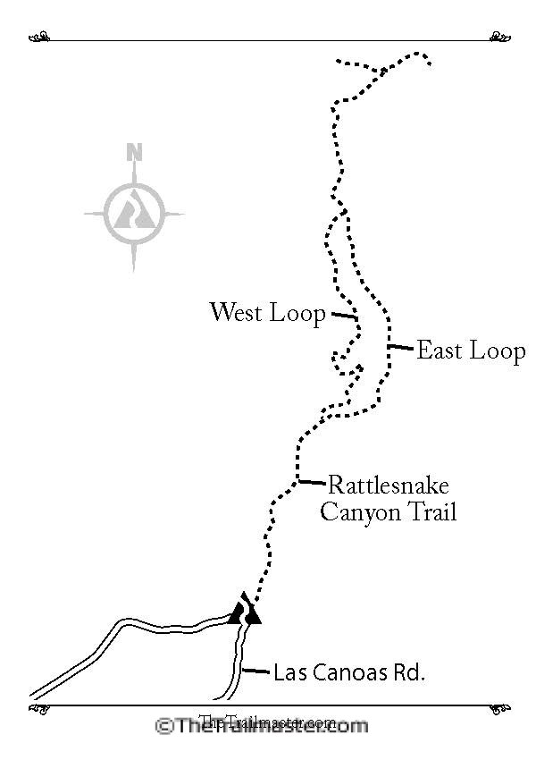
    Rattlesnake Canyon Trail is serpentine, but otherwise far more inviting than its name.

    The joys of hiking the canyon were first promoted by none other than the Santa Barbara Chamber of Commerce. In 1902 the chamber built “Chamber of Commerce Trail,” an immediate success with both tourists and locals, though both trail and canyon continued to be called Rattlesnake.

    In the 1960s, the city of Santa Barbara purchased the canyon as parkland. A handsome wooden sign at the foot of the canyon proudly proclaims: Rattlesnake Canyon Wilderness.

    The canyon was severely burned in the Tea Fire of November 2008, but the chaparral community in particular has recovered quite well from the devastation. Red-berried toyon, manzanita with its white urn-shaped flowers, and purple hummingbird sage cloak the slopes.

    DIRECTIONS TO THE RATTLESNAKE CANYON TRAILHEAD

    In Santa Barbara, follow State Street to Los Olivos Street. Head east and proceed a half mile, passing by the Santa Barbara Mission and joining Mission Canyon Road. Follow this road past its intersection with Foothill Road and make a right on Las Canoas Road, continuing to the trailhead, located near the handsome stone bridge that crosses Rattlesnake Creek. Park alongside Las Canoas Road.

    Rattlesnake Canyon Map by Mark Chumley (click to enlarge)
    Rattlesnake Canyon Map by Mark Chumley (click to enlarge)

    THE HIKE

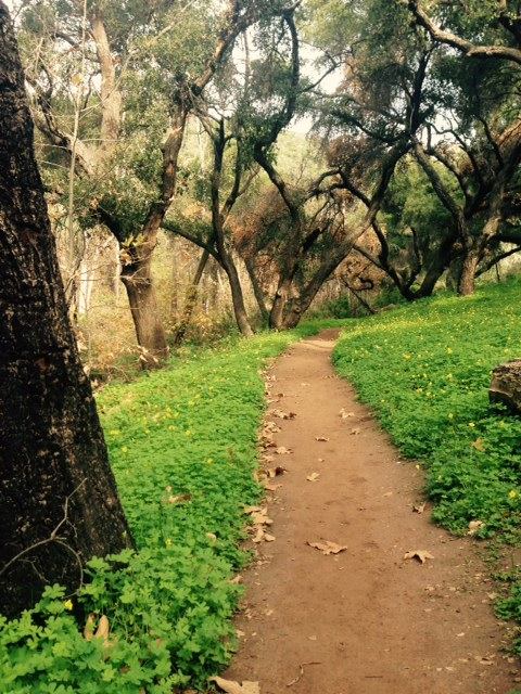
    From the Rattlesnake Canyon Wilderness sign, head north and soon rock-hop across the creek. A brief ascent leads to a trail that parallels the east side of the creek.

    After a half mile, an unsigned trail veers off to the right. (One of The Trailmaster’s favorite byways, this narrow path leads along and above the east bank of Rattlesnake Creek and reunites with the main trail in about a mile.)

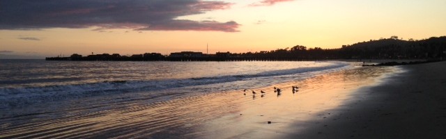
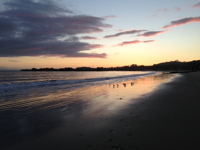
    Soon after the junction, the main trail draws near the creek and crosses it. The path then ascends past remnants of a small stand of planted pines and into the open for good vistas of coast and ocean. Continue to a creek crossing and notice (you can’t miss it, really) a large flat rock in the middle of the creek known by locals as “Lunch Rock.”

    Let's have coffee! These happy hikers visited Tin Can Shack in Rattlesnake Canyon in 1916.
    Let’s have coffee! These happy hikers visited Tin Can Shack in Rattlesnake Canyon in 1916.

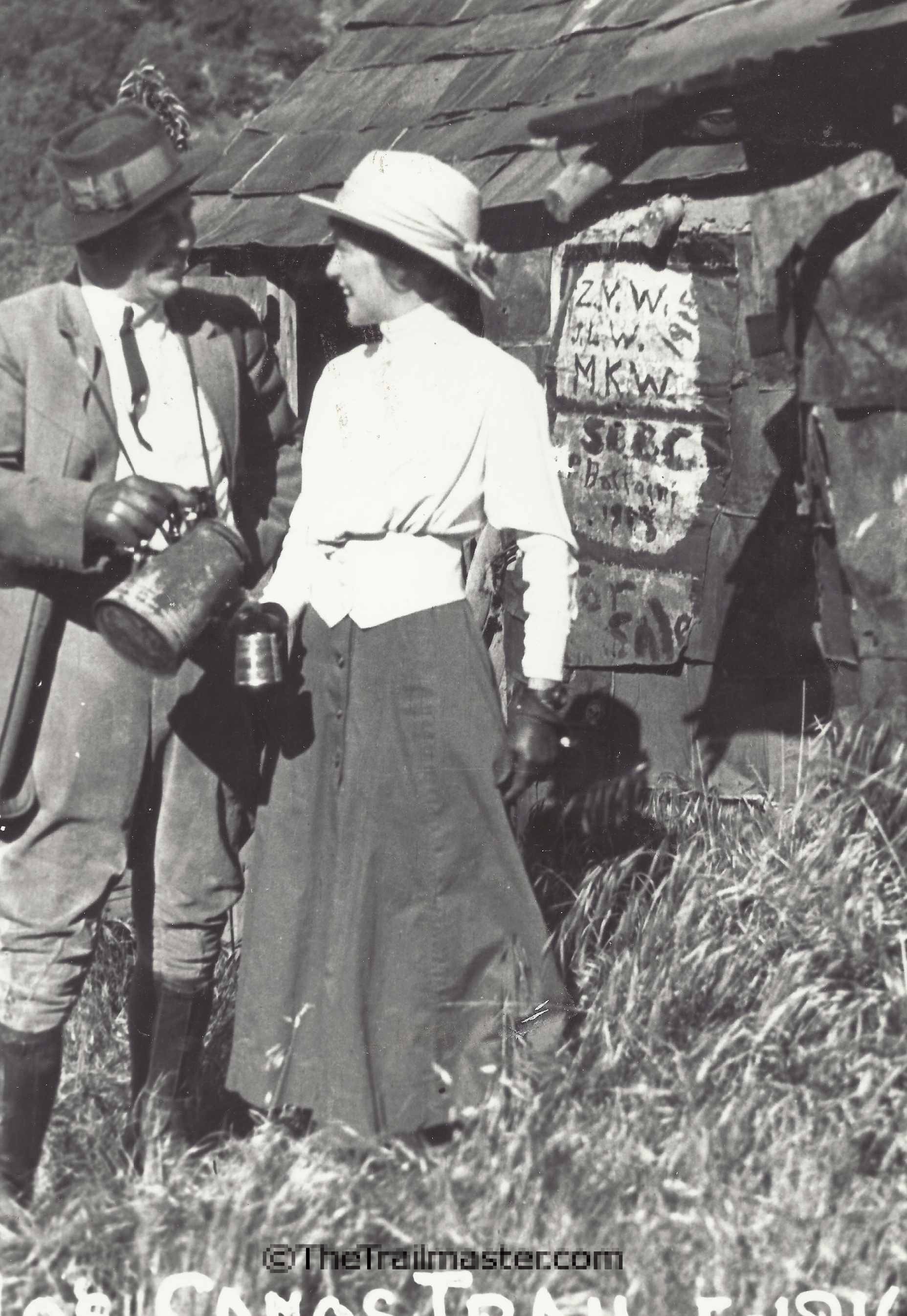
    The trail crosses the creek again, continuing along the west bank to open, grassy Tin Can Meadow, named for a homesteader’s cabin constructed of chaparral framing and kerosene can shingles and sidings. For the first quarter of the 20th century, Tin Can Shack was a canyon landmark, mentioned in guidebooks of that era. A 1925 brushfire destroyed the shack.

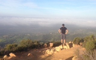
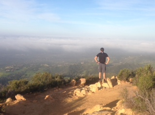
    The apex of the triangular-shaped meadow is a junction. The trail bearing left leads 0.75 mile and climbs 500 feet to an intersection with Tunnel Trail. To the right, Rattlesnake Canyon Trail climbs 0.75 mile and 500 feet to meet Gibraltar Road. The hiker’s reward is an unobstructed view of the South Coast.

    Interested in more hikes in Santa Barbara? Check out HIKE Santa Barbara

  • Santa Barbara’s More Mesa Offers Hiking and More

    Santa Barbara’s More Mesa Offers Hiking and More

    More Mesa offers more: a defacto nature preserve, great bird-watching, a network of walking-hiking trails and access to Santa Barbara’s most isolated beach. I’ve been hiking More Mesa for more than 30 years, and it’s been my great pleasure to share this hike in my guidebooks for nearly that long.

    The More Mesa Preservation Coalition held a symposium recently to remind locals and conservationists statewide about the wonders of nature the mesa holds and the perils of development it could face.

    Birds galore over More Mesa, including the showy white-tailed kite.
    Birds galore over More Mesa, including the showy white-tailed kite.

    More Mesa has a diversity of habitats and attracts an abundance of bird life. It’s known for its bird life, including 16 different species of raptors. The white-tailed s kite, marsh hawk and other raptors, are quite active over the mesa in their pursuit of prey. Rare birds include the northern harrier and short-eared owl.

    This land has been threatened by development for decades. And it still is, though any development scheme faces vociferous opposition. Prominent Saudi developer Sheikh Khalid S. Al-Shobily purchased More Mesa in 2012, but has not announced any development plans.

    The mesa was once part of Thomas More’s Rancho La Goleta, who bought it in 1857 and grazed cattle here. More noticed natural tar seeping from mesa cliffs, gathered it up and sold it to the city of San Francisco, where the asphaltum was used to pave city streets.

    A mile-long walk up a residential street, across the bluffs, and down the cliffs on a combo stairs-pathway leads to a clean, mellow and sandy beach. More Mesa is a great walk without going down to the beach. The property is honeycombed with trails.

    More Mesa Coastal Trail: One of Trailmaster John McKinney's favorite Santa Barbara hikes.
    More Mesa Coastal Trail: One of Trailmaster John McKinney’s favorite Santa Barbara hikes.

    I like hiking a 2.5-mile loop around mesa. If you’re new to More Mesa, I suggest taking a counter-clockwise route. Head for the stairs to the beach, then take the path extending up-coast along the oceanside edge of More Mesa. Choose from a narrow footpath at the very edge of the bluffs or a wider one paralleling and enjoy views of the Channel Islanda and of the UCSB campus a few miles to the west

    The Trailmaster likes to walk the full length of the bluffs before turning inland near a line of homes and commercial nursery. (You can also follow the bluff trail to intersect other trails on your right that lead north toward the mountains and dip into oak-filled ravines.) Turn back east, along the inland edge of the mesa, continuing past a profusion of trails to close the loop and rejoin the main trail near the trailhead.

    From More Mesa, take a glorious sunset beach hike up-coast.
    From More Mesa, take a glorious sunset beach hike up-coast.

    Directions to More Mesa:

    From upper State Street at its junction with Highway 154, continue west along State as it becomes Hollister 1.2 miles to Puente Drive. Turn left (south). Puente Drive bends west, undergoes a name change to Vieja Drive, and passes Mockingbird Lane on your left 0.7 mile from Hollister. Public parking is not permitted along Mockingbird Lane; you must park along Puente Drive/Vieja Drive and walk up the lane past gated residential streets to the gated entrance to More Mesa. (Or exit Highway 101 on Turnpike. Head south to Hollister and turn left. Drive a few blocks to Puente Drive and follow above directions.)

    For more information about this hike (and many others), check out HIKE Santa Barbara

  • Inspiration Point Santa Barbara

    Inspiration Point Santa Barbara

    Hike to Inspiration Point Santa Barbara for grand vistas of the city, coast and Channel Islands.

    San Roque Canyon is one of the great pleasures of hiking the Santa Barbara foothills. Fortunately for hikers, the Depression of the 1930s forced San Roque Country Club to cancel its plans and much of San Roque Canyon became parkland rather than a golf course.

    Hike to Inspiration Point above Santa Barbara for grand vistas of the city, coast and Channel Islands.
    Hike to Inspiration Point above Santa Barbara for grand vistas of the city, coast and Channel Islands.

    Jesusita Trail extends 4.5 miles east-west from San Roque to Mission canyons. Between the canyons is a high ridge with viewpoints, including official Inspiration Point. Creekside flora, handsome rock formations, avocado orchards, grassy meadows, power lines and panoramic views are all part of the Jesusita experience.

    Via Jesusita Trail it’s about 2.6 miles round trip with 700-foot elevation gain to the drinking fountain at Moreno Ranch; to Inspiration Point Santa Barbara is 6 miles round trip with 1,200-foot gain

    The trail was the flashpoint for the 2009 Jesusita Fire, which burned more than 8,000 acres and destroyed 80 homes. San Roque Canyon’s native flora has since recovered somewhat and local volunteers have done wonders to re-hab Jesusita Trail.

    Directions: From Highway 101 in Santa Barbara, exit on Las Positas Road and drive north two miles. Continue on San Roque Road, 0.4 mile past its intersection with Foothill Road to the Cater Water Filtration Plant.

    The hike: Descend Jesusita Trail, soon passing a left-branching path that leads to Stevens Park. About a half-mile out, hike past a picnic table and at 0.75 mile reach a signed junction. Arroyo Burro Trail forks left; stay right with Jesusita Trail.

    The path curves and ascends to an open meadow; follow the narrower path along its left edge. About a mile out, cross San Roque Creek, then re-cross it again a few more times. Jesusita Trail parallels a private ranch road and eventually meets it.

    Follow trail signs and continue across Moreno Ranch to the top of a hill and a vehicle gate. Pass through a smaller pedestrian gate to a shady vista point , picnic table and a drinking fountain (the only one found along a Santa Barbara trail!).

    Jesusita Trail leads the hiker through San Roque Canyon up to Inspiration Point.
    Jesusita Trail leads the hiker through San Roque Canyon up to Inspiration Point.

    Inspiration Point-bound hikers will continue down the dirt road into the shady confines of the canyon. At a creek crossing, Jesusita Trail resumes as a footpath, angles over to the south wall of the canyon, and ascends out of San Roque Canyon on a dozen or so switchbacks. Emerge on open, chaparral-cloaked slopes and get grand views of Santa Barbara and the ocean. Passing handsome sandstone formations, travel under power lines to the ridgeline and a junction with the Edison power-line road.

    Head left along the road to meet footpaths leading left (north) and south (right). The leftward path is Jesusita Trail and it leads down into Mission Canyon. Reach Inspiration Point by descending east on the power-line road a short distance.

    Look sharply right for a narrow, unsigned connector trail leading 0.2 mile or so to Inspiration Point, a cluster of sandstone boulders. Views from the 1,750-foot point include the city and coastlines of Santa Barbara and Ventura.

  • Figueroa Mountain Wildflowers

    Figueroa Mountain Wildflowers

    The spring wildflower show on Figueroa Mountain is stunning this year. In previous years of our long, long drought in Southern California, Figueroa Mountain wildflowers went off early, before spring, with little to show—at least for us flower fans hoping to see fields of colorful wildflowers.

    This year on the slopes of Figueroa Mountain, “Earth laughs in flowers,” as the great Ralph Waldo Emerson put it.

    The laugh-out-loud flowers on the mountain are the poppies. They’re here, there, and everywhere along Figueroa Mountain Road and the blanket of orange on Grass Mountain is simply stunning.

    Figueroa Mountain wildflower displays are spectacular. (photo: Los Padres National Forest)
    Figueroa Mountain wildflower displays are spectacular. (photo: Los Padres National Forest)

    Figueroa Mountain wildflowers are many and varied: Johnny jump-ups, fiddlenecks, milk maids, blue dicks, Chinese houses, shooting stars and buttercups. One of my favorite sights is the pink prickly phlox blooming amidst the green serpentine rock formation. If you’re a true Californian, the sight of the poppy, our official state flower, near outcroppings of serpentine, our official state rock, will really make your day.

    And there’s lots and lots of bush lupine. In such abundance, their sweet smell perfumes the air.

    About Figueroa Mountain

    Figueroa Mountain, located in Los Padres National Forest 25 air miles behind Santa Barbara, is one of the most botanically intriguing areas in Southern California. The mountain’s upper slopes are forested with Coulter pine, yellow pine and big cone spruce. Large specimens of California bay laurel and big leaf maple, and picturesque coastal, valley and blue oaks thrive on the mountain.

    And there’s some fine hiking on the slopes of Figueroa Mountain. A favorite of mine is the jaunt through Fir Canyon, heading out on the trail from Davy Brown Camp. It’s a rewarding 7.5 miles round trip (with 2,400-foot elevation gain) to hike up to Figueroa Mountain Lookout. There are some well-designed (and wheelchair accessible) nature trails atop the mountain, too.

    But back to the Figueroa Mountain wildflowers. Off Figueroa Mountain Road, below the Davy Brown trailhead, are generous displays of California poppies and bush lupine, with plus fiddlenecks and phacaelia, Above the Davy Brown trailhead are more poppies along with buttercups and shooting stars and…

    Well, you get the picture. Take some short hikes off Figueroa Mountain Road and find the earth, at least on the slopes of Figueroa Mountain, laughing with flowers.

    Hike On,
    The Trailmaster
    John McKinney

    P.S. Interested in more hikes near Figueroa Mountain? Check out HIKE Santa Barbara

  • Hike the Santa Ynez Valley Wine Country

    Hike the Santa Ynez Valley Wine Country

    Hike the Santa Ynez Valley Wine Country and enjoy a couple of short trails that lead from tasting room to tasting room. Located near the little town of Los Olivos, the “Foxen Canyon Wine Trail” offers a tour from winery to winery along Foxen Canyon Road. The tour is for motorists (and some cyclists) but I’m happy to report there’s also a hiking trail to take in Foxen Canyon.

    Unwind, uncork, and take a hike in the Santa Barbara wine country.
    Unwind, uncork, and take a hike in the Santa Barbara wine country.

    Perched atop a commanding mesa overlooking Zaca Canyon, the Santa Ynez Valley and the wilderness beyond, Firestone Vineyard is the oldest (established in 1972) estate winery in Santa Barbara County. The large (by valley standards) winery produces acclaimed Merlots, Chardonnays and Rieslings. And it boasts the first and only hiking trail, too,

    During the 1990s, winery founder Brooks Firestone represented the county in the State Assembly for a few terms, before returning to expand the family business. From the earliest days of wine touring in the Santa Ynez Valley, Firestone Vineyard has been a major player and must-stop.

    Hikers were pleased when Firestone constructed “Brooks’ Trail” around the vineyard. The pleasant pathway connects Firestone Vineyard with the former Curtis Winery tasting room, recently taken over by Andrew Murray Vineyards.

    Andrew Murray wines are much admired, particularly for fine Rhône varieties, and it’s probably a safe bet that The Trailmaster is the one and only person who associates Andrew Murray wines with hiking. Let me explain:

    Mountain and (Santa Ynez) Valley vistas are highlights of Brooks' Trail.
    Mountain and (Santa Ynez) Valley vistas are highlights of Brooks’ Trail.

    A decade ago, when I was leading hiking tours of Santa Barbara for an upscale walking vacation company, Andrew Murray Vineyards was quite hospitable to our hiking groups. Andrew’s Mom (Fran Murray) was active with a wonderful group, the Santa Ynez Valley Women Hikers, and she and Andrew gave us permission to walk their property and then arranged a post-hike wine tasting. A couple times, Andrew himself did the pour and proudly explained where he wanted to go with the family business. For some of the hikers on my tour, it was the highlight of the week!

    So here’s a toast to the Murrays, winemakers and hikers.

    If you have a designated driver (always a good idea if you’re on a tasting tour), you can make this an even easier 1.2 mile one-way hike (mostly downhill) from Firestone to Curtis.

    Plan your hike for a time when Firestone Vineyard’s tasting room is open, usually 10 A.M. to 5 P.M. daily. The main gain is open a little before and after these hours.

    For a little more wine country hiking, pay a visit to Zaca Mesa Winery, which occupies a scenic plateau overlooking Foxen Canyon. The winery offers tastings and two short trails, which look a bit neglected these days. Windmill Trail (0.25 mile) climbs to a picnic area then up to a little overlook. Z Trail (0.25 mile) also climbs to an overlook (a popular promontory for exchanging wedding vows). The path winds among the region’s two kinds of oaks—coastal live and valley—helpfully identified by signs en route.

    It's uphill back to Firestone Winery but it's an easy ascent, even after a bit of wine-tasting.
    It’s uphill back to Firestone Winery but it’s an easy ascent, even after a bit of wine-tasting.

    If you’re fantasizing about hiking across the valley from winery to winery and stopping at each tasting room along the trail, you’re going to be disappointed. Sauntering through vineyards in the valley is just not possible or encouraged like it is in Provence and Tuscany. We hikers are grateful to Firestone and Andrew Murray for this small sampling of Santa Ynez Valley wine-country trails, but the valley is so beautiful and enticing, we’re left thirsting for more.

    The signed path begins by the picnic area, located just below the Firestone tasting room. Valley vistas are superb from the start of the trail. The trail descends to the vineyard, skirts rows and rows of grapes, and soon crosses the vineyard’s paved entry road.

    Brooks Trail climbs a bit, then contours along oak-dotted slopes. Enjoy grand views of Foxen Canyon and the greater wine country. The sights and sounds of cars traveling Foxen Canyon and the rise and dip of active oil rigs amidst the rows of grape are also part of the valley scene. The path descends to Andrew Murray Winery and Visitor Center, where there are grassy picnic grounds under the shade of ancient oaks.

    Directions to the Santa Ynez Valley trailhead:

    From Highway 101, some 45 miles north of Santa Barbara, exit on State Highway 154 (San Marcos Pass Rd.) and head east 2.5 miles to Foxen Canyon Road. Turn left and follow the winding road 4.4 miles to a junction with Zaca Station Road. Firestone Vineyard is located 0.7 mile south on Zaca Station Road. Curtis Winery is just west on the continuation of Foxen Canyon Road.

    The most direct route to Firestone Vineyard is to exit Highway 101 on Zaca Station Road and proceed 2.5 miles northeast.

    Interested in more hikes in the Santa Barbara area? Check out HIKE Santa Barbara