Every Trail Tells a Story

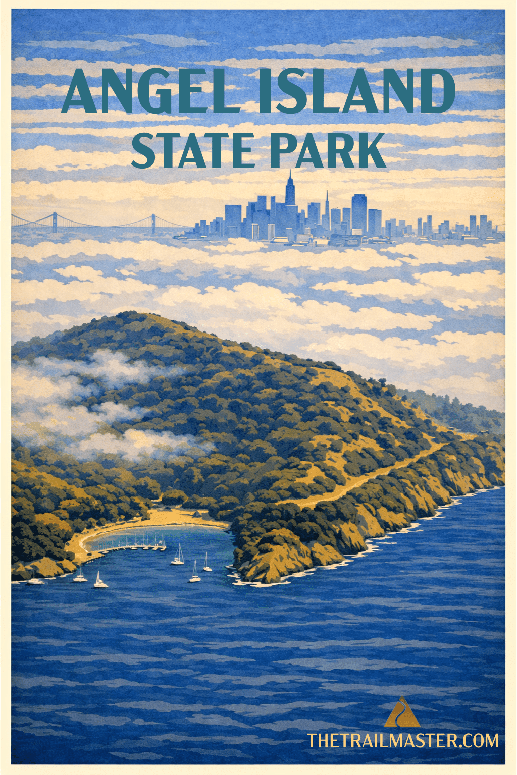
Angel Island State Park
Step into California history: Miwok homeland, Army post, Immigration Station, Cold War missile site
Experience nature in the Bay’s heart: deer, hawks, wildflowers, and 360-degree views
Revel in the hiker’s joy of circling an island, where each turn of trail brings a brand-new panorama
From Tiburon, just north of the Golden Gate Bridge, it takes only ten minutes by ferry to reach Angel Island, but once you step ashore, you’re in another world. A world of layered histories, where each cove and ridge seems to carry a new chapter of California’s story.
The Coast Miwok fished these waters for centuries before the Spanish sailed in. Later, pirates used the coves as hideouts. In Mexican times, Angel Island was part of a land grant. The U.S. Army claimed it during the Civil War, building Camp Reynolds and placing gun batteries to defend San Francisco Bay.
Then came the age of quarantine. Returning soldiers with tropical diseases were isolated here. Immigrants too-especially Chinese-were detained at the infamous Immigration Station between 1910 and 1943. Under the Chinese Exclusion Act, thousands waited here in limbo, their futures determined by interrogations and bureaucratic suspicion. Many carved poems into the barracks walls: poems of longing, anger, and resilience. Reading them today is one of the most moving experiences in the entire State Park system.
And Angel Island’s military career didn’t stop there. It served as a staging point for World War II troops, then as a Nike missile base during the Cold War. Only later, through the perseverance of conservationists and the vision of State Parks, was the island transformed into what we know now: a sanctuary of history and nature in the very heart of San Francisco Bay.
Rocky coves and sandy beaches, grassy slopes and forested ridges, plus a fine trail network, add up to a hiker’s delight. The five-mile Perimeter Road gives a grand tour of the island, with new views around every bend-San Francisco’s skyline, the Golden Gate Bridge, Mount Tamalpais, Alcatraz. Sunset Trail climbs to the island’s highest point, 781-foot Mount Caroline Livermore, for a 360-degree panorama that’s breathtaking on a clear day and mystical when the fog drapes the Bay like a theater curtain.
This isn’t just a walk through the past-it’s a living natural experience. Deer graze the meadows, hawks circle above the ridges, and in spring, wildflowers paint the hillsides. I’ve hiked Angel Island many times, and each time feels new. Sometimes San Francisco is hidden entirely, swallowed in gray. Then the curtain lifts, and there it is: gleaming towers across the Bay, as though revealed for the first time.
Few state parks combine history and nature in such a small space, and few hikes are as satisfying. Angel Island is a reminder that the Bay itself is California’s most dramatic stage, and we hikers get front-row seats.
From Tiburon, catch the Angel Island-Tiburon Ferry (415-435-2131, angelislandferry.com). The crossing takes 10 minutes. Limited ferry service also runs from San Francisco’s Pier 41 via Blue & Gold Fleet (415-705-8200, blueandgoldfleet.com). All ferries land at Ayala Cove on the northwest side of the island. Paid parking is available in Tiburon near the ferry dock.
From the ferry dock at Ayala Cove, head for the visitor center, then climb the road to your left. At the hilltop, intersect Perimeter Road and the Sunset Trailhead.
Sunset Trail switchbacks steeply through coastal scrub, opening onto grassy slopes with views of Ayala Cove and Tiburon. Soon you’re at the 781-foot summit of Mount Caroline Livermore, with picnic tables and stellar views.
Continue west on Perimeter Road. Below you lies Camp Reynolds, the island’s Civil War-era garrison, with its old parade ground, mule barn, and barracks. The road bends eastward past Point Blunt, where seals often haul out on the rocks. Then it passes East Garrison, where 30,000 troops once trained each year. Next comes the sobering Immigration Station, with its preserved barracks and wall-etched poems.
Perimeter Road rounds Point Campbell, northern tip of the island, with views of the Richmond-San Rafael Bridge and Tiburon, then descends to Ayala Cove and the ferry dock.