If spring has a signature color along the Central Coast, it’s gold.
At Montaña de Oro, the bluffs don’t just bloom—they glow. Mustard and poppies spill across the hillsides, lupine and verbena add their accents, and the Pacific keeps up a steady drumbeat below. It’s one of those rare places that feels both wild and welcoming, and I’ll say it plainly: this park ranks among my all-time top five of California’s 270 state parks. Every July 19, I celebrate my birthday the best way I know how—with a long hike here, the ocean at my side and the wind in my face.
A few miles down the coast, the story takes a curious turn.
At Point Buchon, the same wildflowers and wave-carved cliffs lead you through a landscape that feels untouched—until, around a bend, you find yourself looking at the Diablo Canyon Nuclear Power Plant. Nature and megawatts, side by side. Only in California.
Full disclosure: in my younger, more combustible days, I was arrested for protesting that very plant. So I half expected to be turned away at the trailhead—“Sorry, Trailmaster, you’re on the blacklist.” Apparently not.
Good news for all of us.
Because these two coastal walks—one a beloved classic, the other a semi-secret—remind us that California’s edge is never just scenic.
It’s storied.
Montaña de Oro State Park
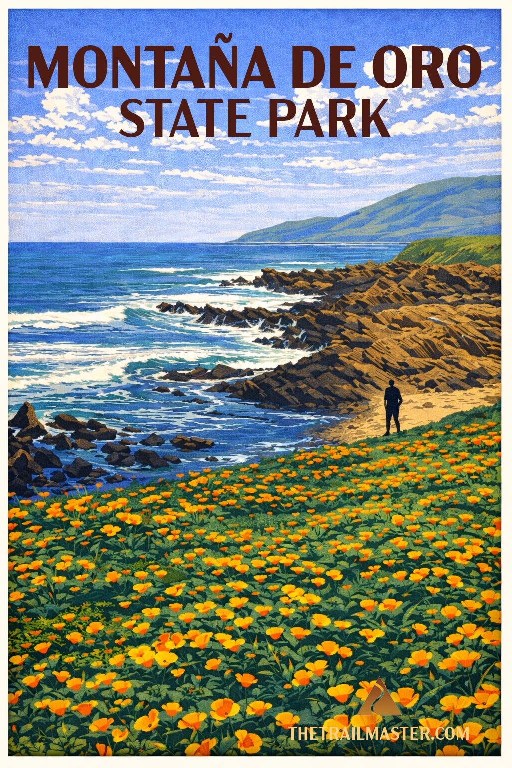
Montaña de Oro means “mountain of gold,” and you don’t need a Spanish-English dictionary to figure out why. In springtime the coastal bluffs glow with golden mustard and poppies, accented by purple lupine, pink sand verbena, and the occasional bright orange nasturtium gone feral. But the name also speaks to the gold standard of hiking along the Central Coast.
This park has everything a hiker dreams of: rugged bluffs, hidden coves, tidepools that could occupy a curious naturalist for hours, even inland trails climbing to peaks and ridges with far-reaching ocean views. Valencia Peak rises 1,347 feet and rewards the stout of heart with a sweeping panorama of Morro Rock, the Morro Bay estuary, and the long blue line of the Pacific. Coon Creek shelters a rare grove of Bishop pines, a southern outpost for this otherwise northern species.
But the signature hike—the one you’ll tell your friends about, the one you’ll tuck away in your memory as one of the great coastal strolls in all California—is Bluff Trail. It’s nearly flat, accessible, and delivers nonstop drama: crashing surf, sculpted sea caves, blowholes, and pocket beaches tucked against the base of golden cliffs.
Montaña de Oro’s story is also human. Much of the park was once Spooner Ranch, where Alexander and Arvin Spooner ran cattle, grew crops, and later rented cabins to tourists. Their old ranch house serves today as the visitor center. Before that, smugglers found Spooner’s Cove a handy place to land contraband, from aguardiente in Spanish colonial days to whiskey during Prohibition. Today it’s family picnics and tidepool explorations that fill the cove—though the wild winds remind you this coast still belongs more to the elements than to us.
And the wildlife! Harbor seals nap on offshore rocks. Sea otters roll in the kelp beds, cracking shellfish on their bellies with polished stones. Offshore, pelicans glide in squadrons, cormorants dive in unison, and the sharp-eyed hiker might even spot black oyster catchers tap-dancing across tide-slick rocks with their neon bills flashing like traffic cones.
This park is both wild and welcoming, a rare combination that explains why so many Californians, myself included, count it among their absolute favorites. If every trail tells a story, Bluff Trail (a 4.2-mile jaunt) tells one of timeless beauty and the endless meeting of land and sea.
Directions, maps, and full trail guide:
Point Buchon
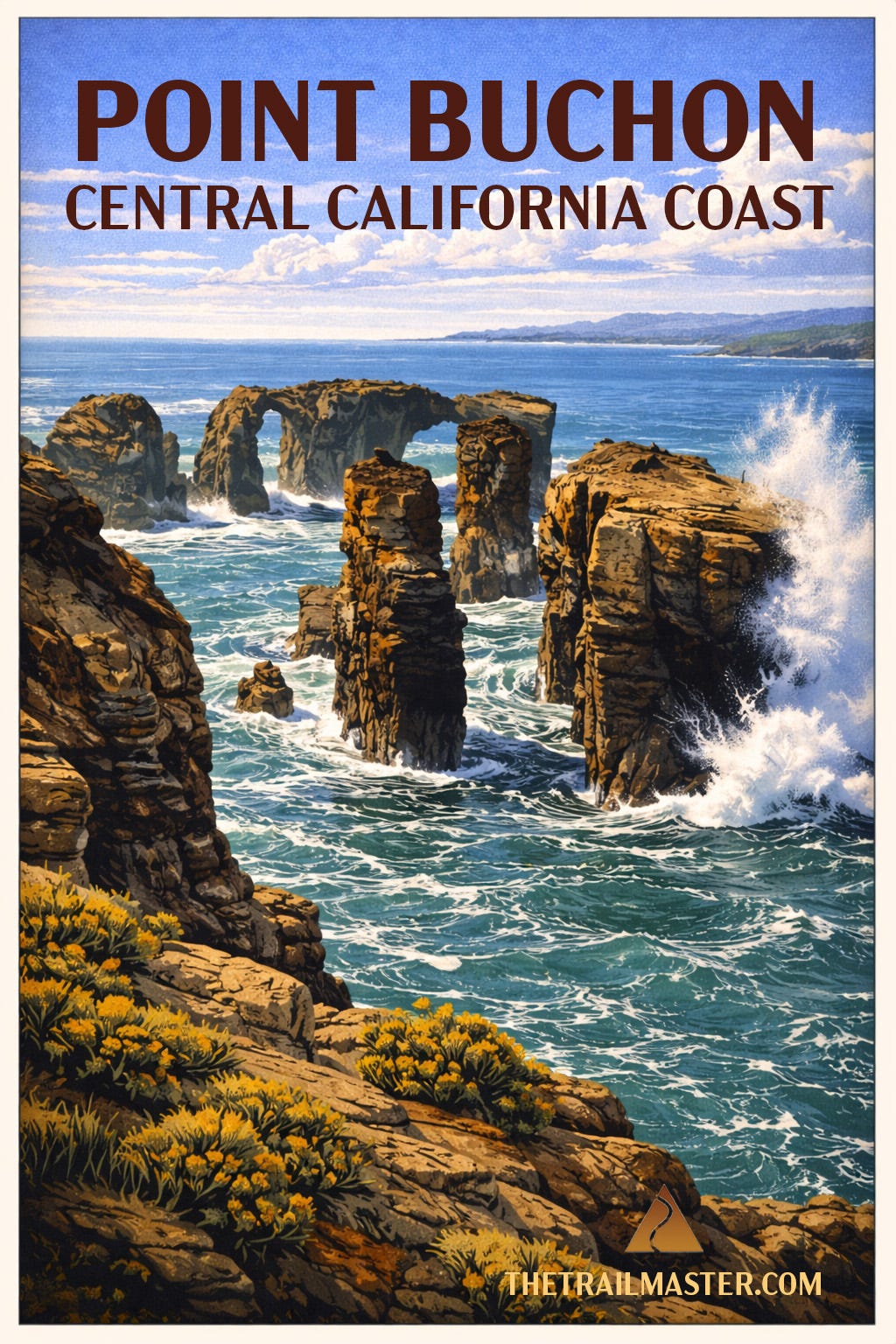
Panoramic vistas from Point Buchon include drop-dead gorgeous headlands, wildflower-strewn bluffs, sea stacks, sea caves and…Diablo Canyon Nuclear Power Plant.
Yes, you read that right. One of California’s most pristine coastal walks is in close proximity to a nuclear facility. Only on the Central Coast do you get this particular pairing: pelicans gliding past sandstone cliffs while, just down the shoreline, engineers monitor reactors designed to keep the lights on from San Luis Obispo to Silicon Valley. Nature and megawatts, side by side.
This rare opportunity to hike PG&E-owned Diablo Canyon lands reveals a portion of 14 miles of coastline that have remained remarkably untouched. No subdivisions, no marinas—just wind, waves, and a landscape that looks much as it did centuries ago. Inland, coastal prairie rolls into oak woodland and pockets of bishop pine, a reminder that this is a meeting place of ecosystems as well as tectonic plates.
The point itself takes its name—somewhat contentiously—from a Chumash leader. Spanish explorers, never shy about creative interpretation, rendered the name “Buchon,” possibly referencing a “goiter” or possibly just getting it wrong. Either way, the land long predates the name, and Chumash presence lingers in the quiet dignity of the place.
Brown pelicans skim the surf in tight formation. Harbor seals and sea otters bob in the kelp beds below. In migration season, gray whales pass just offshore, their blows visible from the bluffs. Red-tailed hawks and kestrels patrol overhead, riding the same coastal winds that may, along this trail, test your balance and your hat.
The trail itself feels like a cousin to Montaña de Oro’s Bluff Trail—same drama, fewer people, more sense that you’ve stumbled into something semi-secret. That’s partly by design. Access is limited (Thursday–Monday, reservations required at the trailhead), and the daily cap keeps things blissfully uncrowded.
And yes, you’ll sign a waiver before heading out. Cliffs, surf, uneven terrain—fair enough. Nuclear meltdown not included. Probably.
Minimal elevation gain makes this an approachable adventure, but don’t mistake “easy” for ordinary. This is the kind of hike where you stop often, not because you’re tired, but because the coastline keeps insisting you look again. Read the full trail guide for this 6.6-mile round trip hike.
Directions, maps, and full trail guide
Footnotes
The northern coast of Montaña de Oro State Park has been described as a “gigantic sand pile.” Park your car at the Sandspit Beach lot. From there, you can head down a hill to the beach between tall sand dunes. Play in the dunes or hike for 4+ miles north toward Morro Rock along the Morro Bay Sandspit, the long finger of sand that separates the ocean from Morro Bay Estuary.
On the drive to the trailhead, I love to stop at Carlock’s Bakery, located at 1024 Los Osos Valley Road in Los Osos. Friendly and family-run, it offers a large variety of daily-baked goods at fair prices: pastries, breads, donuts, and croissants.
Hike On,
John McKinney
The Trailmaster
“Every trail tells a story.”
From the Trailmaster Library
If you’d like to explore more California trails:

Other regions have tall mountains, forests, deserts and an awesome coastline, but only Southern California has all of them – and four-season hiking! You’re guaranteed to find a hike (many hikes!) you’ll like in this “greatest hits” collection. Every Trail Tells a Story. Hike On!
Trailmaster T-shirts & Hats